
Haverhill ZIP Codes at a Glance
Official Massachusetts and USPS material associates four ZIP codes with Haverhill. The Haverhill ZIP code directory should treat them as delivery identifiers, not as verified neighborhood borders. USPS address lookup is the point-of-delivery check for a particular house or business. The state ZIP guide and USPS FAST file establish the four-code set, while municipal property and map records help place a source address in its broader local context.
| ZIP Code | Areas Covered | Post Office | Notes |
|---|---|---|---|
| 01830 | Central Haverhill mailing identity | Haverhill main post office | Verify the delivery point in USPS before relying on a ZIP. |
| 01831 | Haverhill in the official list | Not confirmed by a specific official location result | Do not assign a neighborhood extent without a point check. |
| 01832 | Haverhill in the official list | Not specified in the inspected location material | MapGeo or MassGIS may hold populated site-ZIP fields. |
| 01835 | Haverhill, Bradford, and Ward Hill postal references | Bradford and Ward Hill facilities | Do not treat the entire ZIP as one neighborhood or legal area. |
The USPS Haverhill post-office result identifies the main facility at 2 Washington Square, Haverhill, MA 01830-9998. Official location material also lists Bradford at 135 South Main Street and Ward Hill Station at 19 Cross Road under 01835. Those facilities are postal references, not proof that every address carrying 01835 lies in one named area.
Note: The Haverhill ZIP code directory has no verified official realignment history, so preserve the ZIP printed by the source and verify it against USPS.
Verify a Haverhill Delivery ZIP
Use USPS before attaching a ZIP code to a Haverhill address. The postal service assigns ZIP codes to delivery points, and its lookup is more reliable for an exact current address than a drawn map. The Haverhill main location's posted retail hours are Monday through Friday, 7:30 to 5:00, and Saturday, 7:30 to 1:00; separate PO Box-access hours are posted. The location page is useful for postal contact and service context, not for drawing a ZIP boundary.
The USPS Haverhill location result below is a source for the main post-office record. Use a specific delivery-address check when a Haverhill ZIP code needs confirmation for a mailing or a record search.
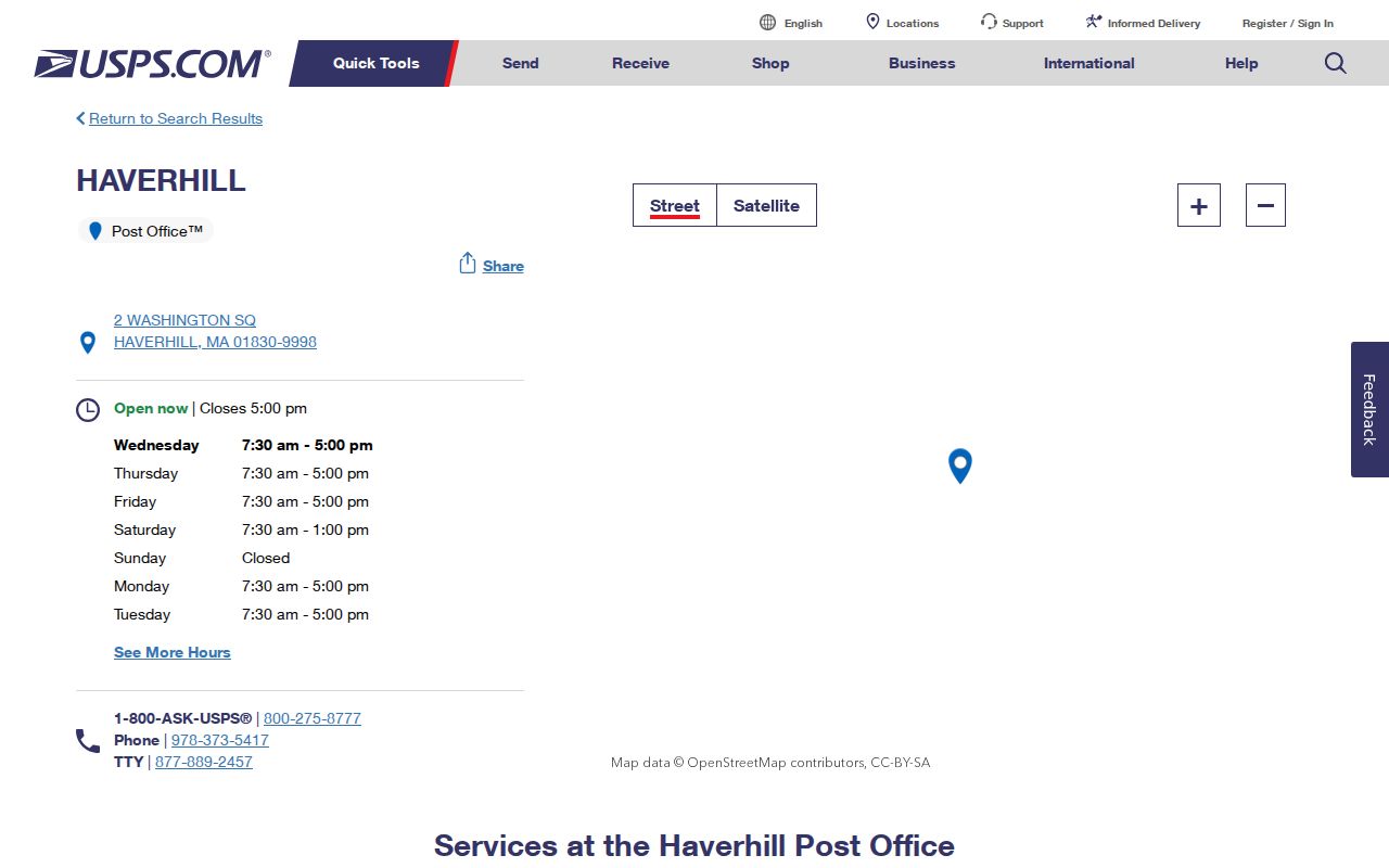
A result for a post office does not assign that ZIP to every nearby parcel. Postal routing and municipal boundaries have different purposes.
Compare Haverhill Site ZIP Fields
ZIP is a useful filter only after the field is identified. MapGeo quick search accepts a street, address, owner, or ID, and advanced search may expose an address attribute based on Haverhill's configuration. MassGIS parcel data separately provides site ZIP and owner ZIP or owner address. A parcel's owner-mailing ZIP can point somewhere other than its Haverhill situs, so it should not be substituted for the postal code of the property itself.
The Haverhill MapGeo property viewer shown below is the local parcel starting point for comparing an address against its source fields before a ZIP is carried into another search.
Check whether a displayed address is the parcel site or the owner's mailing address, then verify the delivery ZIP separately with USPS.
| Tool or field | ZIP input or field | What it helps confirm | Limit |
|---|---|---|---|
| USPS address lookup | Street delivery address | Current delivery ZIP | Not a parcel or legal-boundary map |
| MapGeo quick search | Address, owner, or ID | Haverhill parcel record | ZIP attributes vary by municipal configuration |
| MassGIS parcels | Site ZIP and owner ZIP | Situs-to-mailing distinction | Underlying data has local update cycles |
| Voter registration form | Five-digit registration ZIP | One known voter's status route | Not a ZIP-wide directory |
The MassGIS parcel-field documentation illustrates the site and owner-address fields that must be kept separate. That separation prevents a mailing ZIP from being reported as the parcel ZIP.
Use the field labels and the source date when comparing a MassGIS extract with a current Haverhill MapGeo record.
Map ZIP Without Assuming Boundaries
MassGIS warns that its ZIP geometry is approximate, tied to a Q2 2018 HERE source and then-recent USPS data. USPS does not maintain an official ZIP polygon map. ZIP codes can change, do not equal Census ZCTAs, and do not line up cleanly with parcels. A Haverhill address may therefore need separate checks for postal delivery, city limits, ward or precinct, and parcel location.
The MassGIS property and ZIP-capable map below helps visualize why a map is an aid rather than a final boundary answer. Pair it with the Haverhill parcel record and USPS result for any specific address.
ZIP, ward, precinct, parcel, Haverhill, and Bradford can all appear in a record trail without serving as interchangeable boundaries.
Find Haverhill Records by ZIP
A Haverhill ZIP code directory can narrow an address process, but it is not a list of people. Begin with USPS for the exact delivery ZIP, then use MapGeo or MassGIS to identify a parcel and determine whether the data uses site ZIP or owner mailing ZIP. The state voter form requires the ZIP attached to a known individual's registration. Haverhill tax payment searches by last name or bill number, not by a public ZIP browse.
- Run an exact address through USPS and retain the returned delivery ZIP with the date checked.
- Search Haverhill MapGeo by the address or parcel ID; compare the site address and owner-mailing fields.
- Use MassGIS parcel data for a statewide comparison when its site ZIP and owner ZIP need to be distinguished.
- For a known voter, enter the first name, last name, full date of birth, and registration ZIP in the state form.
- Ask the City Clerk for a lawful, narrow ward, precinct, or local-list record rather than seeking a ZIP-wide personal list.
Once a ZIP result narrows to one street and house number, use the Haverhill by-street directory for the parcel and deed workflow. ZIP is the filter; the precise address is the record key.
Use ZIP in Haverhill Voter Tools
The Massachusetts Voter Registration Search uses ZIP as one required part of a status check. It asks for first and last name, month, day, year, five-digit ZIP, and an agreement checkbox. The state's tips advise using the ZIP on the registration at the time and trying a nickname where appropriate. A recent registration can take two or three weeks to appear.
The statewide registered-voter list is not a public general directory. A public local list has a different request channel through Haverhill City Clerk and excludes phone, email, veteran status, permanent-absentee status, confidential-voter status, and minors' information. The state voter lookup is therefore useful only for the narrow individual-status task it actually supports.
Keep Historic Haverhill Addresses Separate
Old Haverhill directories, voting lists, deeds, and census records normally use a town, street, house number, or legal description, not a modern ZIP code. When following a past household, preserve the original address and date. Use the ZIP code directory only as a current-delivery crosswalk after the historical location has been tied to a parcel, plan, map, or other source.
That approach is especially helpful where a historical entry says Haverhill, Bradford, Georgetown, or Groveland. The 1893 Haverhill Sanborn atlas includes all four names across 47 sheets, which makes it a physical-context aid rather than a postal authority. A modern ZIP should not overwrite the place wording printed in a historical record.
Ask the Right Haverhill Office
When a ZIP search does not answer the question, choose the custodian by record type. USPS can confirm a delivery point and the Haverhill location can be reached at 978-373-5417. Haverhill Assessors, 978-374-2316, can explain a parcel or property-record field. The City Clerk and elections office, 978-374-2312, can explain a local voter-list request, ward, precinct, or municipal street-list access. MassGIS is the statewide parcel-data source when a site and owner address need comparison.
For a records request, identify the Haverhill address, ZIP as printed by the source, parcel ID if known, agency, date range, requested fields, and preferred electronic format. The Haverhill public-records request route is the fallback when a custodian does not offer a web search. Massachusetts Public Records Law permits access subject to exemptions and applicable fees. It does not make a postal code a substitute for an address or a record identifier.
Haverhill ZIP Codes Aren't City Limits
A ZIP code and the Haverhill city limit answer different questions. Postal codes are assigned to delivery points and may touch or cross municipal boundaries. Parcel boundaries come from local land records. Ward and precinct boundaries come from election administration. Treat a ZIP as a locator, then check the appropriate record if the question concerns a municipal address, a property, or a voting district.
The research did not identify a legally authoritative Haverhill parcel-to-ZIP polygon or a confirmed local ZIP-realignment history. That absence matters. Do not label 01831 as a neighborhood, or say that all of 01835 belongs to Bradford, when the official material does not support it.
- ZIP versus ZIP+4
- A five-digit delivery-area code plus a more specific four-digit add-on for a narrower delivery segment.
- PO Box ZIP
- A postal code used for box service, which should not be treated as a residential-area boundary.
- Unique ZIP
- A ZIP assigned to one organization or high-volume destination; none was confirmed for Haverhill in the research.
- Carrier route
- A postal delivery sequence used by USPS, not a legal parcel or neighborhood boundary.
Note: A Haverhill ZIP code helps begin a search, but USPS, MapGeo, the Registry, and the City Clerk each answer different address questions.